


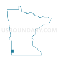
Fountain Prairie Voting District, Pipestone County, Minnesota
About
Outline

Summary
| Unique Area Identifier | 603641 |
| Name | Fountain Prairie Voting District |
| County | Pipestone County |
| State | Minnesota |
| Area (square miles) | 37.03 |
| Land Area (square miles) | 37.01 |
| Water Area (square miles) | 0.01 |
| % of Land Area | 99.96 |
| % of Water Area | 0.04 |
| Latitude of the Internal Point | 44.14694060 |
| Longtitude of the Internal Point | -96.25585360 |
Maps

Graphs
Select a template below for downloading or customizing gragh for Fountain Prairie Voting District, Pipestone County, Minnesota


Neighbors
Neighoring Voting District (by Name) Neighboring Voting District on the Map
- Aetna Twp. Voting District, Pipestone County, MN
- Altona Twp. Voting District, Pipestone County, MN
- Grange Twp. Voting District, Pipestone County, MN
- Hope Twp. Voting District, Lincoln County, MN
- Lake Benton Twp. Voting District, Lincoln County, MN
- Rock Twp. Voting District, Pipestone County, MN
- Troy Twp. Voting District, Pipestone County, MN
Top 10 Neighboring County Subdivision (by Population) Neighboring County Subdivision on the Map
- Troy township, Pipestone County, MN (289)
- Hope township, Lincoln County, MN (272)
- Lake Benton township, Lincoln County, MN (241)
- Grange township, Pipestone County, MN (203)
- Aetna township, Pipestone County, MN (194)
- Fountain Prairie township, Pipestone County, MN (188)
- Rock township, Pipestone County, MN (182)
- Altona township, Pipestone County, MN (153)
Top 10 Neighboring Unified School District (by Population) Neighboring Unified School District on the Map
- Pipestone Area School District, MN (7,718)
- RTR Public School District, MN (3,529)
- Lake Benton Public School District, MN (1,395)